The journey to get to Rough Rider Falls turned out to be a bit of an adventure. I had read from a couple of different sources that the quickest way to get there was to bushwhack through the woods rather than hike for a little more than five miles along the Rogue River Trail. Made sense to me, so I plugged the GPS coordinates into my mapping software along with the hundreds of others I scoped out for the trip.
I worked my way north along the Rogue River this day, stopping at a couple of waterfalls in the morning before ending up at National Creek Falls on the east side of the Rogue shortly after noon. After shooting there for an hour, I told the GPS to head to my next destination, Rough Rider Falls. The logical way to get there would be to turn around and backtrack to the highway and head up north, but the GPS had another plan. I decided to humor it (as I often do…), thinking that maybe it knew a shortcut to the other side of the river. The gravel road soon turned to dirt and then became more of an ATV trail with two tire paths. I followed this though the bushes for a while before emerging into a meadow. I decided to stop and access the situation and pulled out my handheld GPS. Sure enough the falls were less than a mile away. At this point I figured all I had to do was get close and then I could bushwhack in from this side. I really didn’t want to turn around and go back at this point, not when I was this close!
I searched along the edge of the woods for an easy entry point and finally picked the best I could find. I grabbed my gear and turned on the walkie talkies and plunged into the forest. After stumbling over fallen trees and fighting with feisty tree branches, I finally came to the edge. Yikes, it was pretty much straight down for a couple of hundred feet and I still couldn’t see or hear the river. I pondered my options for a bit. I am sure I could scramble (or fall) down to the bottom, but getting back out didn’t sound like much fun. I made the smart decision and headed back to the Jeep.
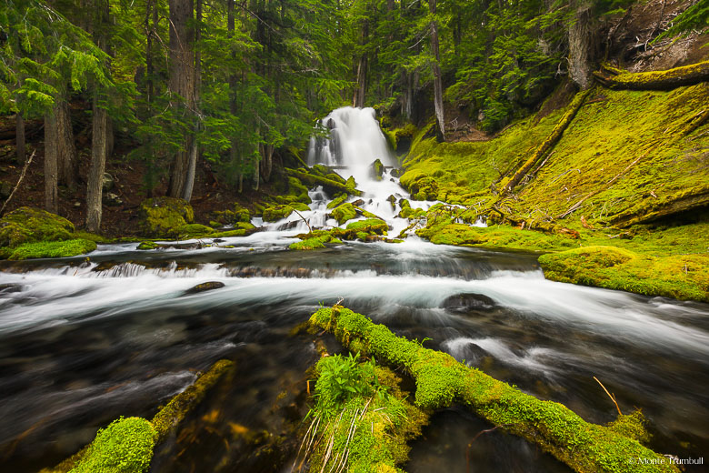
I now needed to get back around to the other side of the river. Once again, I wasn’t excited about going back the way I came, so I pointed the GPS to a spot on the highway close to where I needed to end up. It diligently found a better route and next thing you know I was back on the road to National Creek Falls. I followed the route back to the highway and headed north. It took a couple times turning around on the highway (traffic!) before ending up parking next to where the falls were. The mile hike down was a bit easier on this side and also didn’t have a large drop off involved. I reached the falls and checked my watch. It had been over two hours since I left National Creek Falls, which by the way were only a little over four miles away as the crow flies. So much for taking a shortcut!
Click on the image to view a larger version in the galleries.